









Contour Maps is one of EduElfie's favourite classroom worlds — born out of a real teaching challenge and refined through genuine classroom use.
The Idea
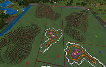
Developed while teaching Year 7 Humanities, this world grew from a simple observation: students struggle to understand what contour maps represent. The three-dimensional, hands-on nature of Minecraft turned out to be the perfect solution.
How It Works
Students walk a custom-built mountain in Minecraft, experiencing elevation changes first-hand. Working collaboratively, they then build a contour map of what they've walked — translating the three-dimensional experience into a two-dimensional representation in the process. In a single lesson, students develop a solid, intuitive understanding of how to read contour maps and what they actually mean.
Who Is It For?
Originally developed for Year 7, this world has since been used successfully across a wide range of year levels. It's a quick, effective lesson that can slot into any geography, mathematics, or STEM unit.
Download
The world file and lesson outline are available to download — get in touch via the contact form for access.
Follow